KAFB Bulk Fuels Facility – Jet Fuel Plume Remediation
Introduction
Leakage of aviation gasoline and jet fuel from the Kirtland AFB bulk fuel facility (BFF) migrated through ~500 feet of dry soil (vadose zone), and into the underlying aquifer.
During migration, the LNAPL partitioned into dissolved, vapor, and adsorbed phases.
Initially, the LNAPL floated on the groundwater surface. Beginning in 2009, the water table began to rise and the LNAPL became submerged and trapped within the groundwater. This “drowned” LNAPL continues to release dissolved EDB and other contaminants into the groundwater.
Benzene and other hydrocarbons are readily biodegraded by native groundwater bacteria. EDB is biodegrading only in the presence of biodegrading hydrocarbons. Once the EDB has migrated beyond the area of hydrocarbon contamination, there is currently no evidence of EDB biodegradation. Understanding the biodegradation of EDB in groundwater is currently an area of interest for technical working groups at this site.
The aquifer contains naturally occurring upward vertical hydraulic gradients. These upward gradients mean that deep groundwater, such as in the zones tapped by drinking water wells, moves upwards into shallower aquifer zones. The upward gradients work in favor of helping to prevent the fuel contamination from moving downward, and offer some protection of the drinking water wells.
Conceptual Site Diagram of KAFB Fuel Leak
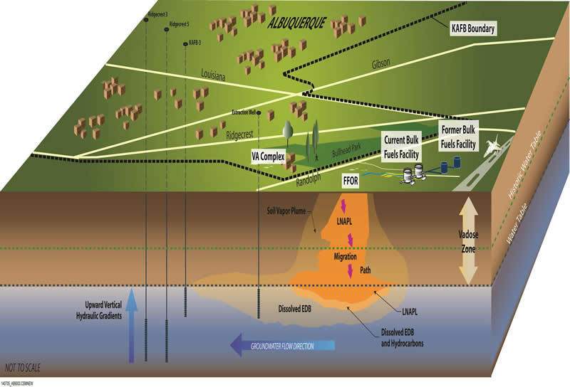
| The conceptual diagram illustrates the current understanding of how fuel migrated through the soil in the vadose zone down to the groundwater. At the Kirtland AFB BFF leak site fuel is found in the four phases: | |
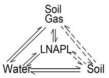 | LNAPL residual fuel;Soil vapor (lighter fuel constituents as vapor in soil);Adsorbed contaminants (fuel constituents attached to soil particles); andDissolved contaminants (fuel constituents in groundwater). |
| Fuel originally floated on the water table but has, over time, become submerged as regional groundwater levels rise. The LNAPL migration path through the subsurface was influenced by the local geology, the properties of the compound and soil, and the height of the water table over time. This conceptual site model continues to be evaluated as data is collected and data gaps are closed.Multiple measures have been implemented in the source area to remove mass of fuel contamination. Almost 5,000 tons of soil contaminated with fuel constituents has been removed through three separate excavation events between 2000 and 2014. Soil vapor extraction (SVE) was initiated in 2003 and has vacuumed approximately 570,000 gallons from soil in the source area. The operation of SVE also facilitated biodegradation of an additional 200,000 gallons of fuel for a total of 770,000 gallons of fuel.The groundwater pump and treat system was designed to:Stop migration of EDB towards drinking water wells;Extract and treat EDB contaminated groundwater; andCollapse the EDB plume back towards the Kirtland AFB boundary. |
Anatomy of the EDB Plume
The EDB plume resides within the groundwater of the Albuquerque aquifer ad is being pulled – very slowly – in a north/northeast direction under the influence of the city’s drinking water wells.
Plume thickness and width vary, but Fourth Quarter 2015 data showed:
- Approximate Width = 1,200 feet
- Approximate Length = 7,000 feet (about 1.3 miles)
The Second Quarter 2017 EDB plume extent varied from the Fourth Quarter 2015. Potential explanations on the difference between the two plumes are:
- The rising water table has resulted in the submerging of 53 of the 62 groundwater monitoring wells screened across the water table; and
- Operation of the EDB plume extraction and treatment interim measures is resulting in the reduction of EDB mass in the aquifer, therefore changing the shape of the plume.
The Air Force will be submitting for NMED review a plan to drill and install new groundwater monitoring wells that will verify the current EDB plume, as well as install a series of sentinel wells that will guarantee the longevity of the early-detection system. Additionally, the Air Force will be utilizing existing wells in the monitoring well network to increase monitoring at the water table within the source area.
