
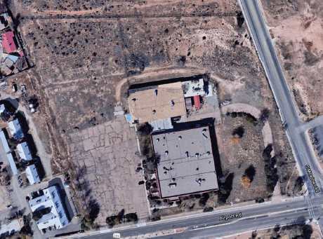
Thermo Eberline Facility
Company Name / Public Involvement: Thermo Eberline LLC
License Number: SO067
Date Posted: 7/24/2025
Location: 5981 Airport Road
Santa Fe, NM 87507
Full Thermo Eberline LLC Decommissioning Plan
- Decommissioning Plan Overview & Summary
- Dated 05/28/2025 Submittal Letter Final Decommissioning Plan (PDF)
- Purpose & Scope, Facility Operating History, & Description
- Radiological Status of Facility, Dose Modeling, ALARA Analysis, and Planned Decommissioning Activities
- PM & Organization, Health & Safety During Decomm, Environmental Monitoring & Control
- Radioactive Waste Management, Quality Assurance, & Facility Radiation Surveys
- Financial Assurance
- *Glossary of Acronyms & Abbreviations
- *Supporting Documentation & Attachments
11.0 Radioactive Waste Management Program
The following is a detailed description of the radioactive waste management program as documented in the Thermo Eberline LLC Final Decommissioning Plan.
11.1 Overview
A Radioactive Waste Management Program (RWMP) will be developed for implementation at the site during the decommissioning and is designed to control radioactive waste generated as part of the decommissioning process in accordance with NMED, NRC and DOT requirements. The RWMP will be implemented using appropriate methods and procedures based upon recognized RCB, NRC and industry standard guidance documents as applicable.
While no radioactive waste is anticipated in the execution of Phase 1 or Phase 2, Phase 3 will result in the generation of LLRW. This section describes practices to ensure that the radioactive waste streams (i.e., types, volumes, and activities) generated by decommissioning operations are properly identified and controlled up through final disposal and/or reclamation at a facility that is licensed and permitted to receive the material. In instances where known contamination of soil requires removal, or is discovered, appropriate remediation efforts will be undertaken. These efforts will require management and control of LLRW. Therefore, the purpose of this section is to describe the Licensee’s commitment to implement suitable waste management procedures for the management of LLRW.
The United States Congress enacted the Low-Level Radioactive Waste Policy Act (Public Law 96-573), which encouraged the use of interstate compacts to provide for the establishment and operation of facilities for regional management of low-level radioactive waste. Under this statue each state is responsible for providing for the management of commercial low- level radioactive waste generated within its borders. This DP incorporates necessary directives outlined below to properly manage radioactive waste generated during the work to be conducted during decommissioning activities. This will include preparation and submittal of waste shipment applications as required by the Rocky Mountain Low-level Radioactive Waste Compact.
11.2 Solid Radioactive Waste
Solid radioactive waste generated during decommissioning is expected to be limited to Class A materials. The purpose of the RWMP is to ensure that controls on the solid radioactive waste stream generation, storage, handling, and disposal and/or reclamation will be protective of public health and safety and in accordance with NMAC requirements.
The solid waste management program will include the following:
- Identification of the types of solid radioactive waste that are expected to be generated during decommissioning operations including (but not limited to) a small portion of the concrete slab (< 2 cyds) and soil (<123 cyds).
- Identification of the estimated volume, in cubic feet, of each solid radioactive waste type expected to be generated following identification. The estimated volume of radioactive waste consisting of soil, concrete and IDW is estimated to be less than 125 cyds.
- Identification of the radionuclides (including the estimated activity of each radionuclide) in each estimated solid radioactive waste type.
- Estimate the volume of Class A solid radioactive waste once identified.
- Establish an on-site segregation and storage (prior to disposal and/or reclamation/recycling) area for solid radioactive waste.
- Establish treatment and packaging requirements and activities for stored wastes to conform to the waste acceptance criteria (WAC) for the intended disposal and/or reclamation facility.
- Establish and document transportation and disposal (T&D) requirements necessary to conform to DOT requirements prior to shipment.
- Implement containment measures to prevent contaminated materials from being re-disbursed after segregation and during on- site storage for disposal.
- Establish the name and location of the intended disposal and/or reclamation facility for solid radioactive waste expected to be generated during decommissioning operations. The expected disposal facility for LLRW is EnergySolutions Clive located at Clive, Utah.
There are currently no hazardous wastes present at the Licensee’s facility. As a result, no mixed waste (radioactive and hazardous) would be generated when radioactive waste is generated. In addition, the identification of potentially impacted building materials and contents will include the segregation, management of materials and containment of waste for disposal as dry solid wastes, such that no liquid radioactive wastes will be generated.
11.3 Solid Wastes (Non-Radioactive)
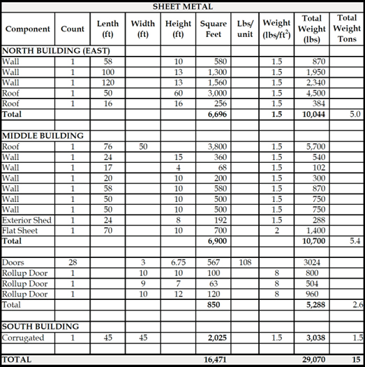
The primary structural components of the South, Middle and North Buildings include: 1) I-Beam Steel; 2) Aggregate based materials including concrete, pre-cast concrete roof, brick, cinder block, stone; and 3) Sheet Metal (corrugated, flat sheet, doors, etc.). A rough estimate of the volume and/or weight of these primary structural elements for all three buildings was generated to support demolition planning (excluding slabs) and is summarized in Tables 11-1 through 11-3 and below:
- I-Beam Steel – 538 linear feet of varying size estimated at 37 tons.
- Total Aggregate – 874 cyds (as demolition debris).
- Total Pre-Cast Roof- 719 cyds of pre-cast (in-place estimate).
- Sheet Metal – 16,500 square feet estimated at 15 tons.
Table 11-1: Steel I-Beam Estimated Quantities
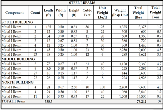
Table 11-2: Concrete Estimated Quantities
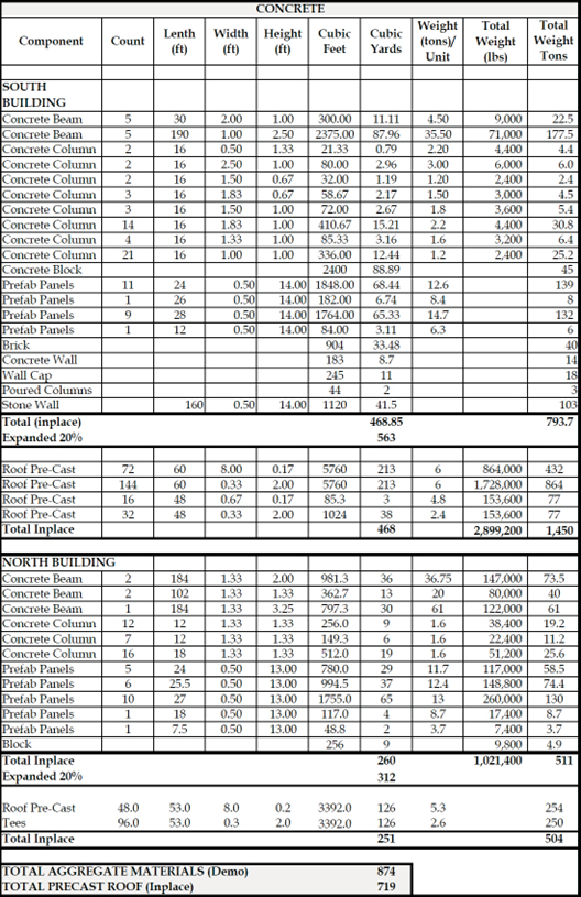
Table 11-3: Sheet Metal Estimated Quantities:
The above estimates were developed for comparative purposes and actual volumes and weights of demolition debris are likely to vary. Nevertheless, comparison of the estimated volumes for pre-cast concrete roof of the South and North Buildings (in-place) with the estimated volume of aggregate debris to be generated in demolition (20% expansion) of the remainder of the building indicates that the pre-cast roof elements approach the entire estimated volume of the aggregate debris to be generated in building demolition.
CN will develop a demolition plan with the demolition contractor to coordinate building dismantlement and radiological screening of materials to facilitate segregation of impacted materials from non-impacted materials, if present, and to further verify the unimpacted nature of the building materials prior to shipment for off-site recycling and/or disposal.
12.0 Quality Assurance Program
The following is a detailed description of the quality assurance program as documented in the Thermo Eberline LLC Final Decommissioning Plan.
12.1 Overview
CN is committed to having all activities affecting the quality of site decommissioning be subject to the applicable controls of the CN Quality Assurance Program (QAP) and associated procedures.
The purpose of CN’s corporate QA policy is to ensure that site decommissioning activities are performed using approved written procedures by trained individuals and properly calibrated instruments that are sensitive to the potential radiological contaminants. This policy applies to decommissioning project activities performed by CN and its suppliers and subcontractors for the duration of site decommissioning. These project activities include design, implementation, data analysis, reporting of results of characterization surveys, FSS and other surveys performed in support of DPs.
CN employs experienced decommissioning professionals – to include Health Physicists with advanced degrees and those certified by the American Board of Health Physics – to ensure that technical and quality assurance procedures required to implement the QA program are consistent with regulatory, licensing, and QA program requirements and are properly documented and controlled. Procedures developed for decommissioning purposes are drafted, independently reviewed, and approved by these professionals.
The corporate QA program requires routine assessments to confirm that activities affecting quality comply with the QA program. These assessments are typically performed by personnel who do not have direct responsibilities in the area they are assessing. Elements requiring assessment are described in the corporate QA program. A description of organizational responsibilities and the QA program elements requiring assessment are described in the corporate QA program.
Assessment of the scope, status, adequacy, and compliance with the QAP is accomplished through audits performed in accordance with a site- specific CN Radiation Safety Audit Assessment Plan.
All personnel responsible for performing activities affecting quality are instructed to execute the applicable procedures as written. If the procedure cannot be executed as written, personnel are instructed to stop work and identify the issue with CN’s management for resolution and if needed, revision of the procedure, before proceeding.
Oversight of quality related activities is conducted by experienced decommissioning professionals – to include Health Physicists with advanced degrees and those certified by the American Board of Health Physics – to ensure that instructions, procedures, and drawings include quantitative acceptance criteria and qualitative acceptance criteria for determining that important activities have been satisfactorily performed.
12.2 Control of Measuring & Test Equipment
Test and measurement equipment utilized for calibration is limited to a TSI 4040 air calibrator. This unit is calibrated annually by the manufacturer, and this piece of equipment is not subject to daily checks. The calibration documentation generated by the manufacturer is kept on file with all other calibration documentation.
Measurement equipment used in detecting radiation is calibrated at least annually by third parties holding specific licenses to provide calibration as a service issued by either the NRC or an Agreement State. This equipment is subject to a response check using sources of radiation emitting types of radiation similar to those for which surveys will be conducted daily prior to use.
Maintained instrument documentation consists of calibration records for all instruments, source calibration certificates where applicable, and the result of each response check measurement regardless of pass or fail outcome. Each measuring instrument will have a unique set up performed and unique acceptance criteria that will be established shortly after the instrument is received from calibration, such that should the instrument’s calibration become impaired it would be detected as a statistically anomalous failure in daily response checks.
12.3 Corrective Action
The CN Corrective Action Program will be used to address corrective actions associated with decommissioning activities. The purpose of this program is to identify unwanted conditions, to properly classify those conditions with regard to quality and safety, to conduct the commensurate level of cause analysis, to assign the appropriate corrective actions, and to trend conditions for ongoing assessment of performance.
Conditions are identified by all CN personnel by initiating a Condition Report. CN personnel screen Condition Reports and assign the applicable significance level to the Condition Report in accordance with the program requirements. CN personnel then conduct an evaluation of the condition and assign a corrective action owner and assign corrective actions with associated due dates as needed to address the condition commensurate with the significance level of the condition.
Corrective action documentation is reviewed by CN personnel for completeness and accuracy before the Condition Report is closed. Condition Reports are trended to provide a mechanism for the discovery of negative trends in performance and/or ineffective corrective actions. Documentation is maintained in accordance with the program and stored in corporate files. The corrective action program is one of the components of the annual review of the radiation protection program with an emphasis applied to the effectiveness of corrective actions.
12.4 Quality Assurance Records
Quality Assurance (QA) records are defined and managed in accordance with the CN Quality Assurance Program requirements. QA records are maintained on site as needed to support site activities with subsequent storage in CN corporate offices either in hard copy or electronic format.
The QA organization consists of the Licensee’s RSO, CN Corporate Management, CN RSO, Project Manager, Health Physicists, Site Managers, Survey Technicians and Subcontractors. The CN QA organization responsibilities regarding DP implementation are outlined in Section 12.5.2 Quality Assessments.
QA records are maintained on site as needed to support site activities with subsequent storage in CN corporate offices either in hard copy or electronic format.
12.5 Audits & Surveillances
12.5.1 Maintenance of the QA Plan
Quality assessments will be performed by decommissioning professionals – to include Health Physicists with advanced degrees and those certified by the American Board of Health Physics to provide assurance that quality- related activities meet applicable requirements.
This QA Plan will be the basis for quality assessments and for necessary response actions. Quality assessments will evaluate whether technical and regulatory requirements are met as well as procedural conformance. Changes in QA policy and procedures will be documented in a timely fashion. Active contractors and affected personnel performing remediation work will be given timely notification of changes to the QA Plan to keep them apprised of the current requirements.
12.5.2 Quality Assessments
Quality Assessments are conducted in accordance with the CN QAP.
CN Management personnel have responsibilities for:
- Providing a high-level of senior leadership, oversight, and direction of work necessary to ensure the quality and consistency of deliverables supporting project objectives.
- Overseeing the development of the site DP and ensuring supporting documentation is completed in accordance with project and site-specific objectives, industry standards, including NUREG-1757, NUREG-1575, Rev. 1 (MARSSIM & MARSAME), and relevant and applicable regulatory requirements and guidance documents.
- Working with site Project Managers to ensure seamless integration of DP requirements into project execution plans and survey procedures.
- Ensuring training, qualifications and competencies of decommissioning leadership assigned to sites are adequate.
- Serving as the primary liaison between decommissioning project management and regulatory agencies, stakeholders, or other interested parties.
- Ensuring decommissioning personnel have completed applicable initial training requirements and requalification of training requirements.
- Documenting and maintaining training records for DP personnel at a site.
- Maintaining required documents and records for the DP organization in accordance with applicable records retention requirements.
- Ensuring project execution is conducted in accordance with applicable license requirements.
Project Managers have responsibilities for:
- The development of site DPs and supporting documents (e.g., Technical Support Documents).
- Assisting with personnel staffing and the procurement of needed equipment and instrumentation.
- Arranging for and coordinating with subcontractors that are needed for DP development and supporting documents.
- The coordination and planning needed for implementation of the assessment, characterization, remediation in support of site DPs.
- Ensuring site work activities are performed in accordance with the QAP and applicable regulatory guidance.
- The management of CN personnel and subcontractors assigned to the project.
- Ensuring that CN personnel and subcontractors provide evidence of the qualifications and training.
- Ensuring all contractual and licensing obligations, as they pertain to DP development, site characterization and FSS, are satisfied.
Health Physicists have responsibilities for:
- Contributing to the development of procedures, technical support documents, and other program documents.
- Providing direction and oversight of CN staff responsible for conducting radiation survey work.
- Contributing to the development of the DP.
- The technical review of radiological survey data in support of assessment, characterization, remediation, and regulatory compliance surveys.
- The development of sample plans and providing technical direction for the implementation of assessment, characterization, remediation, and regulatory compliance surveys.
- Performing data review, verification, and assisting in data validation.
- Preparing reports to document the results of assessment, characterization, remediation, and regulatory compliance surveys, as necessary.
- Maintaining a program for the calibration, set-up and repair of the on- site radiological survey instrumentation and analytical equipment.
- Advising the DP Site Manager and providing direction and support for project sampling activities, including sample collection, preparation, handling, storage, and shipment, and ensuring that all requisite instrument QC and MDC criteria are met.
- Supporting the review and selection of instrumentation for assessment, characterization, remediation, and regulatory compliance surveys.
- Preparing survey maps, layout diagrams, composite view drawings and other graphics, as necessary, to support survey design and reporting of assessment, characterization, remediation, and regulatory compliance surveys.
- Providing direction for the collection and laboratory analysis of volumetric material samples assessment, characterization, remediation, and regulatory compliance surveys.
Site Managers have the responsibility for:
- Monitoring compliance with the implementation of survey packages and plans.
- Monitoring compliance with access controls over completed survey areas to maintain the final configuration and ensure data integrity.
- Coordinating and scheduling Survey Technicians to support the schedule.
- Ensuring necessary instrumentation and other equipment is available to support assessment, characterization, remediation, and regulatory compliance surveys.
Survey Technicians have the responsibility for:
- The acquisition and documentation of survey data in accordance with survey instructions and applicable CN procedures.
- Ensuring all radiation monitoring and survey instrumentation is properly calibrated and in good working order.
- Collection of samples in accordance with sample plan instructions and applicable CN procedures.
- Compliance with health and safety plans, radiation work permits and applicable site project plans.
- Oversight of subcontractors and reporting of subcontractor performance and compliance with site project plans to CN management.
Audits and surveillances will be conducted by trained personnel who do not have direct responsibilities for the achievement of quality in the areas being audited. Persons conducting quality assessments will have the authority and access to managers, documents, and records to:
- Identify quality-related problems.
- Make findings and/or directives to resolve quality-related problems.
- Confirm implementation and effectiveness of corrective responses.
- Report deficiencies or non-conformance in accordance with the CN Corrective Action Program.
13.0 Facility Radiation Surveys
The following is a detailed description of the facility radiation surveys as documented in the Thermo Eberline LLC Final Decommissioning Plan.
13.1 Release Criteria
The Licensee has adopted site-specific release criteria that are intentionally conservative and based on scaling the default criteria stipulated in NUREG- 1757, Vol. 1, Appendix B (NRC, 2006) as radionuclide specific release criteria for 15 mrem/yr.
The release criteria listed in Table 5-3 are applicable as surface release criteria for removable or fixed activity on building or material (concrete, asphalt) surfaces and/or as components and volumetric release criteria for materials and soil as a DCGLw. The DCGLw listed in Table 5-3 correspond to radionuclide-specific action limits for unrestricted release corresponding to a TEDE of 15 mrem/yr. The DCGLw are based on adoption of “DandD” default assumptions with the only site- specific modifications being that they are set to a TEDE of 15 mrem/yr (rather than the default 25 mrem/yr) and that the source term is modified for application to subsurface soil by assuming that subsurface soil are relocated over the upper six inch surface of the site and available for exposure by a Resident Farmer.
Compliance with the DCGLw will be established for each licensed radionuclide above background within each survey unit under the procedures established for the FSS under Phase 3 decommissioning. The DCGLw will be calculated as the average concentration of the licensed radionuclide above background across the survey units to be defined in the FSS (see Section 13.4). A DCGLEMC, an elevated measurement comparison, will be employed in smaller areas of elevated activity within the survey unit as applicable.
The release criteria are intentionally over-conservative for the actual conditions at the site in that they are based on screening criteria for a Building Occupancy and Resident Farmer exposure scenarios. In the case of the site buildings, the Licensee will remove and dispose of the buildings off-site so they will in fact not be occupied in the future. Thus, meeting these criteria ensures the materials are suitable for unrestricted release for disposal. In the case of site soil, impacted soils are limited to the subsurface. Since the release criteria are based on a Resident Farmer exposure scenario that assume soil is available for exposure within the upper six inches of the ground surface, meeting these criteria ensures a level of future use for a resident farmer utilizing subsurface soil that is not generally accessible to farming use, but would be protective in the unlikely event that the soils were brought to the ground surface and utilized by a resident farmer. Lastly, setting the release criteria to a 15 mrem/yr versus a 25 mrem/yr TEDE as required by NMAC provides an added 40 percent greater factor of safety to future unrestricted land use.
13.2 Characterization Surveys
13.2.1 Justification for Impacted Media at the Site
Survey measurements and sampling results supporting the basis for justification of impacted and non-impacted media at the site are summarized below:
- The buildings were surveyed through a sequence of scoping surveys beginning in 2008 (DMA, 2008) following termination of licensed operations and followed by several rounds of surveys completed between 2009 and 2019 associated with site characterization and remediation work (CN, 2022c). Impacted areas were addressed through abatement following identification. A final comprehensive characterization of the buildings was completed between 2020 and 2022 in direct coordination with NMED to establish survey goals, survey areas, measurement point spacings, methods, instruments, analytical procedures, MDAs, and release criteria (Appendix C- Final Building Characterization Report). The results of those surveys and analytical testing confirmed that licensed radionuclides were below MDCs and/or NMED release criteria for unrestricted use. Therefore, buildings are classified as non-impacted by licensed radioactive material. A portion of the South Main Building foundation located directly adjacent to the former HRW where removal of Cs-137 impacted soil had been completed is identified as the only potentially impacted portion of the buildings that will be addressed concurrent with Phase 3 (addressed below).
- Exterior ground surface including soil, concrete and asphalt were surveyed in 2009 (ERM, 2009b) followed by comprehensive characterization surveys completed in 2020 in direct coordination with NMED to establish survey goals, survey areas, measurement point spacings, methods, instruments, analytical procedures, MDAs, and release criteria (CN, 2021a). The results of those surveys and analytical testing confirmed that licensed radionuclides were below MDCs and/or NMED release criteria for unrestricted use except for two locations (G95 and G140) located on the east side of the Middle Building near the former loading dock. Excavation and removal of soil at these locations revealed the presence of naturally occurring uranium ore as rock fragments in soil at depths of less than two feet bgs confirmed through laboratory analysis. Soil testing following removal indicated residual levels of naturally occurring uranium isotopes in soil exceeding NMED release criteria for unrestricted use. A subsequent program of soil borings, surveys, and testing of soil in the loading dock area around G95 and G140 indicated no evidence of additional impacts, suggesting that the impacts are limited to locations G95 and G140 (CN, 2021c). The borings encountered a dense caliche at depths of three to five feet below ground surface that limits the residual impacts from naturally occurring uranium ore to shallow depths. The Licensee proposes to removal soil impacts at locations G95 and G140 to background during DP-3. Removal of building foundations, concrete and asphalt surfaces will be completed during DP-2 to enable characterization of soil located beneath these surfaces that is not currently directly accessible. Based on the results of surveys and testing accessible ground surfaces (i.e., those not located beneath the building foundation, concrete or pavement) CN concludes that all areas except G95 and G140 are non-impacted. Since residual impacts at G95 and G140 are greater than six inches in depth, impacted soils at those locations are classified as subsurface soil.
- Subsurface soil impacts associated with a breeched sealed Cs-137 source within the HRW were evaluated through multiple surveys and testing completed during HRW removal in 2010 and subsequent soil characterization and removal in 2011, 2012 and 2017. The details of remedial actions and investigations are summarized in the HSA (CN, 2022c). The 2017 investigation included a detailed evaluation of soil within and around the former HRW to define the lateral and vertical extent of residual soil impact. The extent of impact was delineated based on field surveys of soil cores from a closely space array of soil boings, ISOCS testing of soil samples on site and laboratory testing of soil samples. A copy of this report is provided in Appendix D. The extent of Cs-137 impact remaining in subsurface soil has been estimated to extend four feet in the east-west direction, five feet in the north-south direction and from 6 to 24 feet bgs, centered on the location of the former HRW (CN, 2017). The estimated extent of impact to in-place soil is 20 cyds. The Licensee proposes to remediate impacts to subsurface soil (at G95, G140 and Cs-137 at the former HRW) through removal to background during Phase 3.
- Groundwater off-site was evaluated through the testing of accessible nearby supply well in 2022 (CN, 2022) and on-site through the installation and testing of groundwater in six monitoring wells in 2024 (DBS&A, 2025). The results of groundwater testing on and off-site confirmed no evidence of impact from licensed radioactive material at the site. The only radionuclide reported in groundwater was naturally occurring uranium and decay isotopes of uranium that are well documented as a natural background condition in the Santa Fe area. As a result, the groundwater pathway was eliminated from further consideration.
- There is no surface water on site. There is no impact to groundwater that could result in impact to off-site surface water. Therefore, the surface water pathway is eliminated.
132.2 Field Instruments, Methods & Sensitives
Field instruments for surveys of buildings (Table 13-1) and soil (Table 13-2) are summarized below along with instrument sensitivities. Survey methods generally included a combination of 100 percent scan surveys over accessible areas, followed by collection of smears and fixed-point static measurements for removable and total beta/gamma and alpha emitters at a 10×10 foot grid spacing. A combination of sampling, ISOCS and laboratory testing was used where feasible at selected locations to identify specific isotopes and assess for volumetric contamination present at locations where activity measurements were elevated to 2-3 times background or above applicable NMED release criteria.
Table 13-1: Survey Instruments for Buildings & Estimated Range in Minimum Detectable Activity (MDA)
| Instruments | Application | Range Mininum Dectectable Activity | Total Efficency (4pi) Percent | Window Thickness (mg/cm2) | |
| Alpha (dpm/100cm2) | Beta Gamma (dpm/100cm2) | ||||
| Ludlum Model 43-37-1 Gas Proportional Dectector Paired w/Ludlum Model 2360 Rate Meter | Alpha & beta/gamma Scan | 125 – 200 | 550 – 700 | Alpha- 7.3% Beta/Gamma- 11.48% | 0.8 |
| Alpha & beta/gamma Fixed-Point | N/A | N/A | |||
| Ludlum Model 43-93 or 43-89 Alpha- Beta Detector (ZnS(Ag) and plastic scintillators) paired with a Ludlum Model 2224-1 or 2360 Ratemeter | Alpha & beta/gamma Scan | 115 – 300 | 1,200 – 1,700 | Alpha- 11.25% Beta/Gamma- 11.25% | 1.2 |
| Alpha & beta/gamma Fixed-Point | 45 – 95 | 250 – 400 | |||
| Ludlum Model 3030 Alpha Beta Sample Counter (ZnS(Ag) and plastic scintillators) | Alpha & beta/gamma Removable | 9 – 14 | 60 – 80 | Alpha- 30%-32% Beta/Gamma- 35%-36% | 0.4 |
| Ludlum Model 44-110 Tritium Detector (Windowless Gas Proportional) paired w/a Ludlum Model 2350-1 Ratemeter | Beta Fixed-Point | N/A | 450 – 700 | H-3 ~ 60% as determined by Ludlum | 0 |
Table 13-2: Survey Instruments for Exterior Ground Surfaces (Soil, Concrete & Asphalt) & Estimated Range in Minimum Detectable Activity (MDA)
13.2.3 Laboratory Methods & Sensitivities
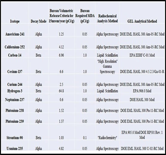
Laboratory analyses were conducted by GEL Laboratories, a nationally recognized laboratory for radiochemical analyses located in Charleston, South Carolina. Laboratory instruments, procedures employed, analytical methods and sensitivity are summarized below (Table 13-3) for each licensed target radionuclide. NMED required MDAs at levels sufficiently below Bureau Volumetric Release Criteria to ensure detection of target licensed radionuclides if present.
Table 13-3: Licensed Target Radionuclides, Analytical Procedures, Sensitivity & NMED Release Criteria
13.2.4 Survey Results & Measurements of Residual Radioactivity
13.2.4.1 Buildings
Results of surveys of the buildings are summarized below from the Building Characterization Report (Appendix C). The levels of residual radioactivity measured in the building are summarized for floors, walls and ceiling by media/substrate (concrete, metal, sheetrock, etc.) for scan, smears (removable) and total fixed-point activity in Appendix C, Tables 3- 5 through 3-15 for PAOC-1 through PAOC-10, respectively. These results were used to support the identification of candidate locations for volumetric sampling and radiochemical analysis according to the following criteria:
- Maximum scan results recorded within each survey grid were compared with reference background activity for that substrate. Locations exceeding 2X’s reference background activity were flagged as candidate locations for sampling and volumetric analysis.
- Fixed-point removable activity as determined through counting of smears collected over 100cm2 were converted to dpm/100cm2. Results exceeding the lowest RCB Surface Release Criteria for removable activity (14 dpm/100cm2 alpha and 4,670 dpm/100cm2 beta/gamma, see Table 5-1) were flagged as candidate locations for sampling and volumetric analysis for each substrate/PAOC.
- Fixed-point static measurements of total alpha and beta/gamma activity in cpm were tabulated for comparison to a calculated screening value (CSV) in cpm corresponding to the lowest RCB Surface Release Criteria for alpha (14 dpm/100cm2) and beta/gamma (4,670 dpm/100cm2) emitters as follows:
- For alpha emitters CSV (cpm) = (14 dpm/100cm2 * Instrument Efficiency) + Reference Background Activity (cpm)
- For beta/gamma emitters CSV (cpm) = (4,670 dpm/100cm2 * Instrument Efficiency) + Reference Background Activity (cpm)
Locations exhibiting fixed-point activity exceeding the CSV were flagged as candidate locations for sampling and volumetric analysis.
- In addition to the above criteria, random locations were selected for sampling for volumetric analysis for each substrate/PAOC. These random locations were selected based on:
- the RCB’s request for additional sampling and analysis (e.g., in PAOC-2, PAOC-4, PAOC-7 and PAOC-8) necessary to meet 95 percent confidence in compliance with NMED Volumetric RCB Release Criteria; and
- at CN’s discretion to confirm volumetric activity in each type of building substrate/material type within each PAOC independent of scan and fixed-point screening results
Of the 2,056 smear results from the 10 PAOCs, none indicated the presence of removable alpha or beta/gamma activity exceeding the lowest applicable RCB Surface Release Criteria for alpha or beta/gamma emitters. In addition, none of the fixed-point total activity results for beta/gamma exceeded the lowest applicable RCB Surface Release Criteria for beta/gamma emitters. As a result, sampling and volumetric analysis was based largely on identification of locations where:
- The maximum recorded scan value was 2Xs greater than reference background activity.
- Where the fixed-point static result for total alpha activity exceeded the CSV (in cpm).
- At random locations selected to confirm volumetric activity even when survey results indicated activity levels below 2X’s reference background, RCB Surface Screening Criteria and/or CSVs.
Employing these criteria resulted in the collection and analysis of 139 samples of which approximately two-thirds of the radiochemical analyses were conducted for alpha emitters and one-third for beta/gamma emitters. Of the 668 laboratory analyses completed on 139 samples, 567 or approximately 85 percent were reported “U,” unidentified above the MDCs.
The remaining 15 percent of analyses with activity reported above an MDC were all reported at levels well below RCB Volumetric Release Criteria for licensed radionuclides. The two samples exhibiting the highest reported activity that approached the RCB Volumetric Release Criteria were concrete floor samples 6-NE-F-7-RS and 6-NE-F-8-RS with levels of Cs-137 at 4.2 pCi/g and 4.8 pCi/g, respectively, as compared to the RCB Volumetric Release Criteria of 6.6 pCi/g. These two samples were collected from the concrete floor in PAOC-6NE adjacent to a cut in the floor slab where Cs-137 contaminated soil had been removed during past remedial actions.
The majority (88 percent) of detected radionuclides reported above MDCs were associated with uranium (U-234, U-235, and U-238) at levels of only a fraction of a RCB Volumetric Release Criteria (e.g., the highest reported concentration of U-235 at 0.0504 pCi/g was in a concrete floor sample (5E- F-4-C) as compared to the RCB Volumetric Release Criterion of 4.82 pCi/g for U-235). A review of all building uranium results indicated that the average percentage, and the associated uncertainties (at one standard deviation), of U-234, U-235, and U-238 are not inconsistent with percentage of naturally occurring uranium as reported by Oak Ridge Institute for Science and Education (ORISE, 2012).
One concrete sample from the ceiling in PAOC-6SE (PAOC-6-C-C-254) indicated a low-level detection of Cs-137 at 0.395 pCi/g, well below the RCB Volumetric Release Criteria (6.6 pCi/g).
The only other licensed radionuclide reported from building testing at levels above MDCs of any significance was Tritium. Tritium was reported at five locations: one in PAOC-6NE (floor sample 6NE-F-56-C) at 1.64 pCi/g; two in PAOC-5E (wall 5E-W-S-67-B-M and wall 5E-W-W-33-M at 1.45 pCi/g and 1.59 pCi/g, respectively); and two in PAOC-5W (floor 5W- F-30-C and wall 5W-W-E-52-A-M at 1.02 pCi/g and 2.58 pCi/g, respectively). The RCB Volumetric Release Criteria for H-3 is 64.8 pCi/g.
CN’s discovery of a record in the building files during the characterization work indicated a reported release of 1 uCi tritium on the floor of the “assembly area” in 1970. While the spill was reported cleaned up to residual levels below 3E-05uCi of tritium (as detected on a wipe sample), the low- level detections of tritium in PAOC-5 and PAOC-6 warranted further evaluation to assess if higher levels of residual tritium may remain in these areas.
In consultation with the RCB, CN conducted additional surveys of PAOC- 5 and PAOC-6 utilizing a Ludlum Model 2350-1 with a 44-110 windowless gas probe to collect static fixed-point one-minute counts on a two-foot spacing over a 90 sft grid (9x10ft) in and around each area of detection and in four additional locations in PAOC-6. This instrument was capable of detecting tritium to an MDA of 450 to 700 dpm/100cm2 verses a RCB Surface Release Criteria of 1.14E+08 dpm/100cm2 (see Table 5-1). The highest level of activity detected in these surveys was 25,103 dpm/100cm2 in an additional grid in PAOC-6NE. These results provided a reasonable level of assurance that higher levels of residual tritium are not present on building surfaces at levels that would approach RCB Release Criteria.
Other low-level sporadic detections reported in the laboratory results, and/or uncertainties in results reported at levels below MDCs were reported for Am-241, C-14, and Cu-244. The very-low levels of activity reported in these samples, and/or the presence of companion analyses of building materials for the same radionuclides in the same PAOC, suggest the reported activity levels of these radionuclides are of little significance with respect to the RCB Volumetric Release Criteria and are within the expected range of potential for false positive results (at less than five percent of detections).
CN concluded that the combined results of surveys and radiochemical analysis of building materials in the areas of highest potential for residual impact of licensed radioactive material (PAOC-1 through PAOC-10) provide sufficient evidence that building surfaces meet RCB Surface and Volumetric criteria for unrestricted release. While these results indicated levels below DCGL’s suitable for release, the Licensee has conservatively assumed that the concrete immediately adjacent to the cut in the floor slab where Cs-137 impacts to soil remain and where the highest levels of activity in all building samples was reported, will be management as LLRW along with the Cs-137 impacted soil.
13.2.4.2 Exterior Ground Surfaces (Concrete, Asphalt & Soil)
Results of surveys and characterization of exterior ground surfaces (concrete, asphalt and surface soil) are summarized below from the Exterior Ground Surface Report (CN, 2021a). The exterior of the site was divided into 10 Survey Areas (Survey Areas 1-10, Figure 13-1). Scanning survey results were evaluated by comparison to reference and local area background readings and complemented with the collection of fixed-point static measurements for total gamma activity at all locations exhibiting elevated gamma activity above the reference background. The range and average gamma activity for reference background areas and site survey measurements for soil (on and off-site), asphalt and concrete are summarized Figure 13-2.
Fixed-point static measurements for total gamma activity were plotted for 10 survey areas covering the entire exterior ground surfaces of the site (Survey Areas 1-10). Total gamma activity is plotted as a fraction of the lowest RCB Volumetric Criteria for gamma emitters, Cs-137 at 6.6 pCi/g and was used as a screening tool to identify areas of higher gamma activity as candidate locations for further evaluation. Results are displayed in Figures 13-3 through 13-11. Note that results for Survey Area 7, the loading dock, were evaluated similarly to the building characterization surveys based on the dual probe instrumentation utilized and are not included in a figure (see CN, 2021a). The calculated fractions were highlighted with a gradational coloring as follows:
- Dark to light green indicates fractions are negative to zero.
- Light green to yellow indicates fractions of zero to less than 1.0.
- Yellow to orange indicates fractions of 1.0 to less than 2.0.
- Red indicates fractions approaching 2.0 or greater.
As indicated in Figures 13-3 through 13-11, the green to yellow shading over most Survey Areas 1-10 suggests that total gamma activity is a small fraction of the RCB Volumetric Release Criteria for Cs-137 and therefore of low relative significance. The yellow to orange or red shading indicates total gamma activity at or above the RCB Volumetric Criteria for Cs-137 and represents locations of greater relative significance. The locations of the highest observed total gamma activity (red) were identified in Survey Area 5 (Figure 3-6, fractions of 2 to 4) and in Survey Areas 8 (Figure 3-8, two locations G95 and G140 where the fraction was 10 and 140, respectively). The results of further evaluation of locations G95 and G140 indicated the source of the elevated activity was naturally occurring uranium ore in fill material.
Correlation of Survey Area 5 survey results with those from the May 2009 gamma survey of the site (Figure 13-12) reported in previous investigations indicated a similar pattern of elevated gamma readings on the west side of the building that was previously attributed to the “planters and building features” such as the courtyard masonry, etc.
Locations exhibiting clusters of elevated gamma readings in Survey Areas 2-6, 9 and 10 and/or drainage pathways were further evaluated for Am-241 by performance of FIDLER surveys at a series of fixed-point locations on the same grid spacing employed for gamma surveys in each survey area. Results of the FIDLER surveys indicated activity consistent with reference background in all areas surveyed (see CN, 2021a).
The circled locations in Figures 13-3 through 13-11 represent locations selected for the collection of samples of soil, concrete, and asphalt for laboratory analysis of targeted licensed radionuclides. Sample locations were generally selected to correspond with locations of the higher total gamma activity relative to surrounding locations. One exception to this was in Survey Area 9 on the east side of the building where the yellow circles indicated 24 sample locations (Figure 13-10, six transects of four samples) collected along transects to further assess the potential for C-14 in soil associated with the spill in the dosimetry trailers formerly located on the east side of the building (as reported in the HSA (CN, 2022c)).
A total of 121 samples of soil, concrete and asphalt were collected in Survey Areas 1 through 10 and submitted for laboratory analysis of target licensed radionuclides. Laboratory results for the 773 analyses completed are summarized in Figure 13-13 and indicated:
- In 65% (501) of the analyses, target radionuclides were reported as not identified (U) at concentrations above MDCs.
- In 4% (30) of the analyses, target radionuclides were reported at concentrations above the uncertainty and below MDCs.
- In 31% (240) analyses, target radionuclides were reported at concentrations above MDCs. Of those target radionuclides reported above MDCs:
- 77% were for U-234, U-235 and U-238.
- 18% were for Cs-137.
- 5% were low levels of Am-241, Cf-252, Pu-238/239, Sr-90 and H-3.
The low levels of Am-241, Cf-252, Pu-238/239, Sr-90 and H-3 were attributed to possible false positive detections since the results were not replicated in the duplicate analysis or verified at very low concentrations for which the identification is uncertain. In all cases the low levels of these target radionuclides were reported at levels well below RCB Volumetric Release Criteria.
The reported levels of Cs-137 were consistent with reference background levels, levels reported in New Mexico from fallout (Englert, D. & Ford- Schmid, R., 2007) and reported at levels well below RCB Volumetric Release Criteria.
The average concentrations of uranium isotopes (U-234, U-235 and U-238) reported in soil, concrete and asphalt are expressed as a percentage of total uranium in Table 13-4. These results are compared to the percentage of uranium reported by ORISE (ORISE, 2012) as naturally occurring and as reported in samples of building materials evaluated on site (CN, 2021). This comparison indicates that the percentages of uranium in soil, concrete and asphalt are consistent with naturally occurring uranium and/or that reported in site building materials.
Table 13-4: Percentage of Uranium in Exterior Soil, Concrete and Asphalt in Comparison to ORISE Naturally Occurring Uranium & Site Building Materials

Results of laboratory testing of soil, concrete and asphalt indicated that the concentrations of target licensed radionuclides were below RCB Volumetric Release Criteria at all locations except G95 and G140 in Survey Area 8. Analytical testing of soil at locations G95 and G140 in Survey Area 8 indicate that elevated gamma activity is associated with the presence of uranium (U-234, U-235 and U-238) which was found to be associated with naturally occurring uranium ore at these two locations.
The two locations of elevated gamma activity identified in Survey Area 8 were located at G95 (60,000 cpm, plotted as a fraction of 10) and G140 (511,000 cpm, plotted as a fraction of 139). Location G95 correlates with a crack in asphalt in survey area 8. Location G140 was located within an unpaved area inside of a shed located on the southern boundary of Survey Area 8.
Further evaluation of G95 and G140 was completed by manual removal of asphalt, soil excavation, soil screening and collection of samples for laboratory analysis. Total gamma reading of excavated soil beneath the asphalt crack at G95 was up to 37,000 cpm while pieces of black rock fragments with green and yellow discolorations indicated gamma activity up to 850,000 cpm on contact using a 3×3 NaI detector (CN, 2021c).
Similarly, soil excavated from an estimated six inches below the ground surface at G140 in the shed exhibited total gamma readings up to 425,000 cpm and larger pieces of angular black rock fragments with green and yellow discolorations indicated total gamma readings up to 616,000 cpm or 3mR/hr at six inches using a Ludlum Model 19 micro-R meter (CN, 2021c).
Both excavations were advanced to an estimated 2×2 feet in width and 1.5 feet in depth. An estimated 10.5 cubic feet of impacted soil was removed, contained and disposed of off-site. Soil samples collected from the floor and four walls (north, south, east, and west) of each excavation were screened and found to exhibit gamma activity approaching, but distinguishable from reference background (24,000 cpm). Samples of the angular black rock fragments with green and yellow discolorations and post-excavation soil samples from the walls and floor of the excavations at G95 and G140 were submitted for laboratory analysis of target licensed radionuclides (CN, 2021c).
The percentage of uranium isotopes reported in rock fragment samples analyzed by alpha spectroscopy from G95 and G140 to the percentages reported by ORISE for naturally occurring uranium ore is presented in Table 13-5 below. These results suggest that the rock fragments discovered at G95 and G140 were similar in composition to naturally occurring uranium ore.
Table 13-5: Comparison of Percentage of Uranium Isotopes in Site Ore to Naturally Occurring Uranium Ore
| Comparison of Percentage of Uranium Isotopes in Site Ore at G95 & G140 to ORISE Percent Natural U | |||||
| Isotope | Sample ESA-8-95 pCi/g | % U | Sample EGS- 8-G140-UOR2 R pCi/g | % U | % U ORISE Natural U |
| U-234 | 14,300 | 48.0% | 6,190 | 48.3% | 49.50% |
| U-235 | 786 | 2.6% | 244 | 1.9% | 2.30% |
| U-238 | 14,700 | 49.4% | 6,390 | 49.8% | 48.30% |
Removal of the observed ore fragments and the surrounding soil indicated reduced gamma activity in post-removal soil that approached background. Laboratory analysis of post-removal soil samples collected from the floor and walls of G95 and G140 indicate substantially lower concentrations of uranium isotopes in soil with the maximum residual levels of U-235 at G95 and G140 reduced below the applicable RCB Volumetric Criteria. However, both the minimum and average concentrations of U-234 and U-238 remain at levels above the comparative criteria for unrestricted release at G95 and G140 (Table 13-6).
Table 13-6: Survey Area 8 – G95 and G140 Post-Removal Concentrations of Uranium (U-234, U-235 & U-238)
| G95 Post-Removal | G140 Post-Removal | |||||||
| Analyte | NMED RCB Volumetric Release Criterion | Minium | Maximum | Average | Minium | Maximum | Average | |
| U-233/234 | 7.8 1 | 15.1 | 43.0 | 27.0 | 12.3 | 41.5 | 23.9 | |
| U-235/236 | 4.82 | 0.7 | 2.1 | 1.2 | 0.6 | 2.8 | 1.3 | |
| U-238 | 8.4 1 | 14.2 | 42.3 | 26.1 | 12.0 | 42.7 | 24.8 | |
| 1- Comparative Criteria for Unrestricted Release | ||||||||
| Bolded values exceed release criteria | ||||||||
The Licensee will remove building foundations, concrete and asphalt surfaces over the site and complete characterization of soil underlying these areas to confirm the presence or absence of impacts from license radioactive material beneath these surfaces during Phase 2. The Licensee proposes to remove residual impacts to subsurface soil from uranium ore at locations G95 and G140 during Phase 3. Any additional areas of impact identified beneath foundations, concrete or asphalt, if present, will also be removed as part of Phase 3 work.
13.2.4.3 Surveys of Subsurface Soil & Residual Impacts from Cs-137 at the Former HRW
The Licensee initiated recovery of all sealed sources contained in calibration wells in November 2007 (TE, 2008). One Cs-137 source was reported to have fallen to the bottom of the HRW and not recovered. Loose Cs-137 contamination was detected, and further source recovery suspended (TE, 2008). The calibration wells, including the breeched Cs-137 source that remained within the HRW, were removed and properly disposed of off-site in 2010 (ERM, 2011). Cs-137 contamination of soil was discovered at concentrations up to 1,220 pCi/g.
In 2012, four borings and a PVC conduit were advanced in the area surrounding the former HRW and gamma logging conducted to support modeling of the contaminated zone (ERM, 2012). Results suggested the contaminated zone was estimated at 1.5 feet in diameter centered on the former location of the HRW and extended up to 19 feet below ground surface. Elevated gamma reading were noted at depths of 7, 11 and 19 feet bgs (ERM, 2012).
In 2013, removal of Cs-137 impacted soil adjacent to the former HRW was conducted by excavation to 8 feet bgs and then by use of a two-foot dimeter auger centered on the former HRW and advanced in three foot increments to remove soil within 2 feet of the former HRW from 8 to 24 feet below grade (TIG, 2013). An estimated 11.8 cubic yards of Cs-137 impacted soil was removed, contained and disposed as LLRW off-site. Four soil boings were advanced adjacent to the north, south, east and west boundaries of the augured removal zone for collection and screening of soil samples for gamma activity and selection for laboratory analysis of soil samples by gamma spectrometry. Results indicated residual Cs-137 impacts to soil at an average concentration of 1,595 pCi/g from 6 to 22 feet bgs with the highest concentration reported 7,960 pCi/g reported at 18-22 feet bgs (TIG, 2013).
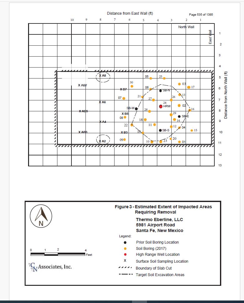
A report by CN summarizing the methods and results of a detailed characterization of residual Cs-137 in soil in the area of the former HRW is included in Appendix D (CN, 2017). The work included the collection of 20 surface soil samples at 10 locations within the 7 x 11 foot cut in the floor slab and the advancement of 30 soil borings up to 28 feet below grade within an area approximately 6 feet x 6.5 feet surrounding the former HRW. Soil cores were collected continuously from the surface to the bottom of each bore (Appendix D, Table 1- Soil Boring Summary).
Surface samples and cores were surveyed with handheld field survey instruments, analyzed with an ISOCS to identify and quantify radionuclide contamination and submitted for laboratory analysis to distinguish between contaminated and uncontaminated zones. Results indicated a perfect correlation (100 percent agreement) between ISOCS and lab analyses with respect to the delineation of contaminated and uncontaminated zones (Appendix D, Table 3- Analytical Summary of Soil Borings).
As a result, the extent of Cs-137 impacted soil requiring removal to background was defined as summarized below.
Detected concentrations of Cs-137 in soil ranged from 0.08 pCi/g to 3,510 pCi/g and averaged 460 pCi/g over an impacted area centered on the former HRW extending 4 feet in the east-west direction, 5 feet in the north- south direction and from 6 to 24 feet below grade. The total impacted soil volume above background (assuming 20 percent expansion upon excavation) was estimated at just under 20 cubic yards (CN, 2017). The extent of residual Cs-137 impacts to soil requiring removal during Phase 3 is summarized in Appendix D, Figure 3.
13.2.5 Classification of Impacted & Non-Impacted Areas
13.2.5.1 Site Conceptual Model
This section presents a site conceptual model to guide in the planning of future site restoration to be completed during site decommissioning and support classifications for areas of the site based on the prior site history, characterization and remedial work completed employing the MARSSIM methodology (NRC, 2000).
Impacted areas of the site are limited to subsurface soil in three locations where residual impacts remain at levels in excess of RCB Release Criteria. The source(s) of release at these three locations (Cs-137 source and uranium ore) have been removed. In addition, remediation of soils at each of the three locations has removed the highest levels of impact and residues remain in soil requiring abatement to background or DCGLs. A conceptual site model has been developed to summarize the source, nature and extent of each impacted area, as described below, to support remedial planning during site decommissioning. A block diagram representation of the conceptual site model is shown in Figure 13-14.
In the case of residual impacts to soil from the breeched Cs-137 source, the source was composed of cesium chloride salt, the majority of which was contained within the HRW and removed during removal of the HRW. The HRW casing was observed to be breeched due to corrosion and resulted in Cs-137 migrating from the well into the nearby soil. Removal of impacted soil within a two foot diameter centered on the former HRW was successful in removing an estimated 70% of the cesium released to surrounding soil. The extent of soil impact remaining in soil above background is very well defined to a volume extending lateral 4 feet by 5 feet and from 6 to 24 feet below grade. The volume of impacted soil is conservatively estimated to be 20 cubic yards in-place. The location of the release beneath the building slab has minimized the infiltration of precipitation into the impacted soil area and hence downward migration to groundwater.
Studies on the fate and transport of cesium chloride in the environment indicate that even if the material is released as a dry particle, such as the Cs- 137 salt from the breeched source, the cesium will become aqueous at relative humidity in excess of 67 percent (EPA, 2018). The aqueous cesium then tends to be transported through porous media and strongly adhere to the surface of that media (soil). The observed damp nature of the silty, clayey soil in borings advanced beneath in the building and the observed distribution of Cs-137 within a few feet laterally from the former HRW suggests the cesium released from the HRW to soil may have transitioned into an aqueous phase in soil moisture and diffused laterally into the surrounding porous silty, clayey soil, becoming strongly adhered to the soil within a few feet around the former HRW.
Evaluation of groundwater quality on and off-site indicates no impact from licensed radioactive material to groundwater. The evaluation of site groundwater quality in 2024 confirmed the presence of groundwater beneath the site at 331 to 336 feet with the Tesuque Formation. Geologic deposits beneath the site include continuous clays, ranging from a few feet in thickness at shallow depths, up to 100 feet in thickness at depth of 135 feet (DBS&A, 2025). These massively thick, continuous, dense clays would also impede the downward migration of Cs-137 to groundwater located at more than 330 feet in depth. In considering the physical characteristics of the site and the source area, the lack of infiltration of precipitation into the impacted soil area due its location beneath the building, the high affinity for cesium to diffuse in soil and adhere to clayey soil, the massive clay layers and the great distance the cesium would need to travel in soil to reach groundwater, CN concluded that there was a very low potential for cesium in soil to impact groundwater beneath the site. This conclusion was further supported by the testing of groundwater on and off-site indicating no impacts from licensed radionuclides, including Cs-137, to groundwater.
In the case of the two locations of residues from naturally occurring uranium ore in soil at locations G95 and G140, it is unknown how the ore came to be located at the site. The potential exists for the ore to have been introduced from an off-site source, for example as a component of the base course of gravel placed prior to paving. Alternatively, depleted uranium was a component of the licensed RAM inventory. Regardless of the origin, the ore was removed and properly disposed of off-site. Residues of the ore remaining in soil are limited to a shallow depth of 2-3 feet and were found to be underlain by a dense caliche several feet in thickness, a deposit of calcium carbonate that is near to a rock in hardness (CN, 2021c). The presence of caliche would limit the ore to a shallow depth above the caliche rendering it readily removed by shallow excavation.
The presence of the ore at G95 and G140 was based on the detection of elevated gamma activity during surveys of the exterior ground surfaces of the site (CN, 2021a). No elevated gamma readings were observed in other area of the site, however, the potential exist for concrete foundations, concrete surface coverings and asphalt to have shielded the gamma emissions for ore located beneath these surface from detection by handheld survey instruments. Therefore, removal of concrete and asphalt surfaces and completion of field surveys will be completed under Phase 2 to ensure no additional areas of naturally occurring uranium ore, or other licensed radionuclides, exist in these areas of the site. Any areas of impact discovered would be addressed under Phase 3 removal actions.
13.2.5.2 Classification of Impacted & Non-Impacted Areas of the Site
The MARSSIM survey design recognizes that all areas of the site do not have the same potential for residual contamination and therefore do not warrant the same level of survey coverage to achieve compliance with NMED RCB Release Criteria (NRC, 2000). Survey design is based on the potential for impact based on the history of RAM use, storage, release, cleanup and post-remedial characterization. The first level of classification is to divide the site into impacted and non-impacted areas. Non-impacted areas have no reasonable potential for residual contamination and do not require additional radiological survey to establish regulatory compliance with release criteria. Impacted areas are those that maintain a potential for some level of residual contamination and are further divided into three MARSSIM sub-classifications (NRC, 2000):
- Class 1 Areas– those that have, or had, known or potential radioactive contamination in excess of DCGLs.
- Class 2 Areas– those that have, or had, known or potential radioactive contamination in excess of DCGLs, but are no longer expected to have residual contamination.
- Class 3 Areas– those that are not expected to contain any residual radioactivity or may contain residual radioactivity at a small fraction of the DCGL.
Non-impacted areas and impacted areas classified as Class 1, Class 2 and Class 3 are summarized in Figure 13-15 for Interior Building Surfaces, Figure 13-16 for Exterior Building & Land Surfaces and Figure 13-17 for Subsurface Land – Located Beneath Buildings, Concrete, Asphalt & Surface Soils.
Non-impacted areas include:
- All interior and exterior building surfaces except for a small portion of the slab in PAOC-6 where soil removal was completed adjacent to the former HRW (Figure 13-15).
- All building contents including both interior and exterior M&E and building systems.
- All exterior land surfaces including soil, concrete, or pavement (Figure 13-16).
- All subsurface soil underlying exposed soil surfaces (Figure 13-17, except Class 2 below).
Impacted areas include:
- Class 1 Areas- Soils within a 4×5 foot area adjacent to the former HRW from depths of 6 to 24 feet below grade exceed the DCGL for Cs-137 and are designated as Class 1 (Figure 13- 17). Soils within a 2×2 foot area to a depth of 3 feet below grade at locations G95 and G140 in Survey Area 8 exceed DCGLs for U-234 and U-238 and are also designated Class 1 (Figure 13-17).
- Class 2 Areas- All soil located beneath building foundations, surface concrete and asphalt pavement are conservatively designated as Class 2 (Figure 13-16, excluding Class 1 Areas above). The identification of natural uranium ore in fill beneath pavement and the potential for concrete and paved surfaces to shield other areas of ore, if present, could impact soils beneath these materials at levels above DCGLs. Soil within the floor cut in PAOC-6 from 0 to 6 below grade may also be impacted by Cs-137 at levels approaching the DCGL and is also designated Class 2. Building concrete on the floor adjacent to the former HRW area also maintains a potential for Cs-137 at levels approaching, or above, the DCGL and is also designated Class 2 (Figure 13-15).
- Class 3 Areas- Building surfaces within PAOC-6 (Figure 13- 15 walls, ceilings, and floors, except the concrete floor cut adjacent to the HRW designated Class 2) are conservatively designated as Class 3 as these areas have been shown not to contain residual activity or to contain residual Cs-137 activity in localized areas at a small fraction of the DCGL.
13.2.6 Licensee Assessment of Characterization Adequacy
This section presents the Licensee’s basis for concluding that it is unlikely that significant quantities of residual radioactivity have gone undetected. The primary criteria supporting this conclusion include:
- The Licensee completed a detailed review of its inventory of licensed radioactive materials present at the conclusion of licensed activities in 2007 to support disposition of the inventory through either transfer for use at other facilities or disposal. CN completed a reconciliation of the inventory to materials transfer and/or disposal records and verified proper transfer and/or disposition of the inventory based on available records (Appendix B).
- Site characterization followed the phased assessment process as outlined in MARSSIM that began in 2008 and included many phases of document review, scoping surveys, characterization surveys, remedial measures and post-remedial assessment extending into 2025. The many phases of work completed at the site included the coordination of site efforts with the NMED RCB in advance of execution, periodic inspections of ongoing work by the RCB, preparation of reports documenting methods and results and expansion of work elements where and when necessary to address RCB comments and requested clarifications (CN, 2022c). Impacts from licensed RAM were addressed to the extent feasible following identification. The multiple phases of review, scoping and characterization surveys provided further confidence in the definition of impacted and non-impacted areas at the site to support the definitions and classifications present in the DP.
- Data generated during the final phase of building characterization was collected to meet a high level of confidence (a 95 percent confidence limit) to confirm the absence of impacts exceeding DCGLs and act as the basis for conclusion that the buildings are non- impacted (see Final Building Characterization Report, Appendix C).
- Data generated in support of characterizing residual impacts to subsurface soil from Cs-137 adjacent to the former HRW also provided a high degree of confidence in delineation of the lateral and vertical extent of residual impact remaining in subsurface soil (Appendix D Part I & Appendix D Part II). Characterization results confirm the expected distribution of Cs-137 in soil as being limited to near proximity to the former HRW. The documented migration characteristics of Cs-137 releases (i.e., high affinity to adhere to clayey soil (EPA, 2018)) support the observed limited migration from the release point. Site- specific characteristics including: 1) the building foundation limiting infiltration of precipitation; 2) boring logs indicating the presence of continuous clay layers beneath the area of soil impact; and 3) the presence of massive, dense clays between the source area and underlying groundwater at more than 300 feet are mitigating factors supporting the low potential for impact to groundwater beneath the site. Testing of groundwater quality on and off-site have confirmed no impacts from licensed RAM at the site. CN’s review of available site records concludes that the breached source in the HRW was a 16.8 Ci Cs-137 source that was removed during well removal in 2011 (TE, 2022). Based on the soil removal completed in 2012 and characterization results from 2017, CN has estimated that 0.06 Ci, or 0.4 percent of Cs-137 was released from the HRW to the surrounding soil and that 99.6 percent of the source was removed within the HRW during well removal in 2011. In addition, prior removal efforts in 2012 are estimated to have removed 69 percent of the impact to soil, leaving an additional 31 percent to be removed during Phase 3 decommissioning (TE, 2022). Thus, the Licensee’s assessment of impacts to soil from Cs-137 are supported by multiple independent lines of evidence providing a high level of confidence in the results.
- Site characterization results also confirmed no impacts to exterior ground surfaces (concrete, asphalt, and soil) except at G95 and G140 where naturally occurring uranium ore was identified in fill (CN, 2021a). While origin of the ore is unknown, available instrumentation provide adequate ability to identify its presence based on gamma surveys. Impacts at G95 and G140 are limited to near surface fill that is underlain by a very dense caliche that serves as a boundary to vertical migration (CN, 2021b). Those impacts will be removed during Phase 3. The removal of concrete foundations, concrete and asphalt surfaces during Phase 2 will be completed to enable surveys beneath these substrates to confirm the presence/absence of additional uranium ore in fill on site, and if present, be addressed during Phase 3.
- Surveys of materials and equipment (M&E) located throughout impacted and non-impacted areas of the site confirmed the absence of impacts from licensed RAM except for HVAC filters, one HVAC duct and one metal cart that were segregated and decontaminated or disposed as LLRW (filters only (CN, 2023)). The location and nature of the impacts to M&E were all traceable to Cs-137 associated with the former HRW remedial efforts, further confirming the established classification of impacted and non-impacted areas of the site based on the evaluation of M&E located throughout the site.
The Licensee therefore concludes that it is unlikely that significant quantities of licensed RAM remain on site that have gone undetected.
13.2.7 Surveys of Inaccessible Areas
Inaccessible portions of the site that were not surveyed include:
- Building surface located behind walls or above hung ceilings.
- Soils beneath foundations, exterior concrete, and asphalt surfaces.
There is a low potential for impacts to exist in portions of the building located behind walls or above remaining hung ceilings since no impacts were identified above DCGLs in the accessible portions of the building where licensed RAM use, storage, disposal and or release was documented. Nevertheless, screening of building demolition debris will be conducted during Phase 1 decommissioning to confirm the absence of impacts in the waste materials being generated as non-impacted C&D waste prior to shipment off-site.
Survey of foundation surfaces, exterior concrete and asphalt surfaces have indicated no evidence of impact of licensed RAM above DCGLs. The presence of naturally occurring uranium ore in fill located beneath pavement, while detectable, has raised the question of potential impacts from licensed RAM existing beneath exterior concrete and asphalt surface and foundations that are inaccessible and may have gone undetected due to the shielding effect of concrete and asphalt. As a result, the Licensee will remove the foundations, concrete and asphalt surfaces during Phase 2 decommissioning and complete added characterization of currently inaccessible soils located beneath these surfaces.
13.2.8 Multiple Radionuclides & Ratios in FSS
The Licensee proposes to reduce the levels of licensed RAM on site to background. Since impacts are limited to specific radionuclides (Cs-137 and residue of naturally occurring uranium) in subsurface soil from different sources located within different survey units of the site, the Licensee concludes that multiple licensed radionuclides ratios are not expected to be needed for consideration in the FSS but will be if conditions warrant.
13.3 In-Process Surveys
Radiological surveys conducted during decommissioning activities will be primarily targeted towards detection of Cs-137 and natural uranium ore; however, equipment will also have sensitivity to other alpha and beta emitters, such Am-241 and Sr-90, respectively.
Characterization surveys to date have not identified impact to the building, and follow-on surveys during decommissioning will be intended to confirm the absence of impact above the accepted release criteria on both building surfaces and ground volumetric media.
CN’s field monitoring instruments have detection capabilities for Cs-137, or other beta emitters like Sr-90, that are in the range of 80-400 dpm/100cm2 depending on environmental factors. These values are significantly lower than the lowest established release criterion for surfaces of 4,670 dpm/100cm2 for Sr-90. Established detection capabilities for alpha emitters are less than 50-100 dpm/100cm2 depending on environmental factors. While these values are higher than the lowest established screening criterion, there was no history of detection of alpha-emitting radionuclides during characterization work. In instances where activity is measured discernable from background, supplemental collection of volumetric samples may be used to confirm the absence of alpha constituents below applicable release limits. Analysis for such emitters may be conducted on site via gamma spectroscopy, ISOCS or off-site via alpha spectroscopy at an analytic laboratory.
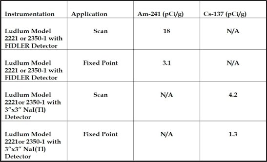
Surveys of volumetric media such as soil, concrete, and asphalt will be conducted using a 3”x”3 NaI(Tl) detector capable of detecting Cs-137 in volumetric media at approximately 20 percent of the established release criterion of 6.6 pCi/g. Further measurements of soil may be made using a low-energy gamma detector such as a FIDLER, capable of screening for gamma emissions from Am-241 at levels approaching (3 to 8 pCi/g), but still above the release criterion of 1.25 pCi/g. As such, measurements by field instruments may be supported by sampling and laboratory analysis in order to assess for Am-241 at levels below 1.25 pCi/g release criteria.
Prior to waste being removed from the site, whether radiologically impacted or not, the waste will be subject to survey via a NaI(Tl) detector, either a Ludlum model 19 micro-R meter utilizing a 1”x1” crystal and having established overresponse to low-energy photons or a 3”x”3 NaI(Tl) detector with higher general efficiency.
13.4 Final Status Surveys
13.4.1 Overview
A FSS will be conducted following the completion of all remedial work to demonstrate that site conditions following remediation meet criteria for unrestricted release of the site (i.e., meet a TEDE of 15 mrem/yr). Based on discussions with RCB, it was agreed that the scope and design of the FSS will be included as an element of Phase 3 in order to account for any changes in site area classifications determined during site decommissioning and ensure appropriate classification of FSS survey units.
The FSS will be conducted to demonstrate compliance with the requirements for license termination for unrestricted use by demonstrating that residual radioactivity that is distinguishable from background radiation, if present, results in a TEDE to an average member of the critical group that does not exceed 15 mrem/yr, and that the residual radioactivity has been reduced to levels that are ALARA (see Section 6). The FSS design is based, where applicable, on NRC guidance found in the MARSSIM (MARSSIM, NUREG-1575) and the NRC Consolidated Decommissioning Guidance (NUREG-1757).
The primary objectives of the FSS are to:
- Select/verify appropriate survey unit classifications.
- Identify and perform appropriate measurements in each survey unit which are of sufficient quantity, quality, and representativeness to support final decision making.
- Demonstrate that the potential dose or risk from residual contamination is below the release criterion for each survey unit.
The Licensee proposes to complete restoration of the site to activity levels consistent with background. This will be accomplished through the removal and off-site disposal/recycling of non-impacted buildings, foundations, concrete and asphalt surfaces. Radiological impacts to a portion of the concrete slab and subsurface soil will be addressed by removal to background, if feasible, or to meet 15 mrem/yr, if background is not feasible. Demonstration of achievement of background, or a 15 mrem/yr TEDE if background is not feasible, will be completed through the performance of a FSS over the undeveloped natural soil surface of the site, as well as sampling to meet MARSSIM criteria for subsurface removal.
13.4.2 Preliminary Survey Design
This section includes a preliminary design for the FSS based on information available at the time of DP submittal to satisfy requirements of NUREG-1757 for FSS design. The FSS design may be modified based on site-specific results.
The FSS will include:
- Scanning 100 percent of the soil surface of the site in Class 1 areas, at least 50% of the surface of the site in Class 2 areas and at least 10% of the surface of the site in Class 3 areas.
- Collection of direct measurements of gamma fixed-point activity within each survey unit as necessary to satisfy sampling requirements under MARSSIM.
- Sampling and laboratory analysis of soil by alpha, beta and gamma spectroscopy for target licensed ROCS at distinct locations within each survey unit as necessary to satisfy sampling requirements under MARSSIM.
- Preliminary site area classifications of non-impacted and impacted areas as Class 1, 2 and 3 are summarized in Section 13.2.5.2 and displayed in Figures 13-15 through 13-17 and will be updated as necessary for site decommissioning results. Site decommissioning will include the removal of non-impacted buildings during Phase 1. Phase 2 will include the removal of non-impacted building foundations, concrete and asphalt surfaces followed by implementation of characterization surveys and sampling of soils previously covered by building foundations, concrete and asphalt. CN has conservatively classified soil located beneath foundations, concrete and asphalt surfaces as Class 2. Results of additional surveys of these areas following removal of building foundations, concrete and asphalt surfaces may warrant re- classification of soil within these areas (e.g., as non-impacted or Class 1 or Class 3). Phase 3 will include the removal of impacted subsurface soil within Class 1 areas.
- For FSS planning purposes CN has assumed that the site area (11 acres of land estimated at 44,422 square meters (m2)) will be divided into survey units of at least: 1) 2,000 m2 Class 1 areas; and 2) 10,000 m2 for Class 2 and Class 3 areas.
- The statistical tests recommended in MARSSIM are the Wilcoxon Rank Sum (WRS) Test and the Sign Test. CN proposes to utilize the WRS Test at the site since Cs-137 is found in background due to fallout from weapons testing and uranium is found to be naturally occurring.
- The background reference areas to be utilized during FSS were established during site characterization and are displayed in Figure 2-3. Background was evaluated for the on-site locations in Figure 2-3 and compared to off-site reference background levels for field instruments (see Figure 13-2) and concentrations as determined by laboratory analysis in soil, concrete and asphalt (see Table 4-1).
- A description of the scanning and handheld instruments to be utilized in the FSS including instrument sensitivities and MDAs is summarized in Section 13.2.2.
- The collection, control and handling of samples during FSS will follow CN SOPs and be relinquished to GEL Laboratories for analysis of target ROCs using the analytical methods and procedures summarized in Section 13.2.3.
- A summary of inaccessible areas that were not surveyed and will be addressed during site decommissioning is addressed in Section 13.2.7.
- The success of remediation within a survey unit, variance of results and compliance of survey units with the applicable DCGLw will be based on the collection of direct measurements and analytical testing of soil samples. The number of samples required for each survey unit will be determined using the minimum detectable scan concentration for Am- 241 (the least sensitive target ROC to detection with field instruments at 18 pCi/g Table 13-3) and calculated using the following equation:
Area Factor = Scan MDC (actual)/DCGL
Using the scan MDC of 18pCi/g (Table 13-3) and the DCGLw for Am- 241 at 1.25 pCi/g (Table 13-1) yields an Area Factor of 14. Using MARSSIM Table 5.6 as guidance, the area was estimated at 100m2. Thus, the minimum number of samples required for a 2,000 m2 survey unit would be 20 (2,000 m2/100 m2). The actual number of samples to be collected for each survey unit will be determined using a conservative lower end value calculated for the relative shift (i.e., a minimum of 20 or greater as required under MARSSIM in Table 5.6). - The sum of the fractions rule described in MARSSIM will be used where appropriate to account for multiple ROCs, if present, in a survey unit. This rule effectively lowers the DCGLw for each ROC when more than one ROC is present in a survey unit. This accounts for the multiple ROCs to ensure that the dose criterion is not exceeded.
13.4.3 Final Status Survey Report
The results of the FSS will be summarized as part of the DR for the site. The DR will be compiled to satisfy the requirements of NMAC 20.3.3.318(K) and include:
- A completed certificate of disposition of radioactive material form certifying that all licensed material, including wastes, have been properly dispositioned from the site.
- A radiation survey, i.e., the FSS Report.
The FSS Report will include the following elements as recommended under NUREG-1757 (Appendix D Checklist):
- An overview of the results of the FSS.
- A discussion of any changes that were made in the FSS from what was proposed in the DP or other prior submittals.
- A description of the method by which the number of samples was determined for each survey unit.
- A summary of the values used to determine the number of samples and a justification for these values.
- The survey results for each survey unit, including:
- The number of samples taken for the survey unit.
- A description of the survey unit, including (a) a map or drawing of the survey unit showing the reference system and random start systematic sample locations for Class 1 and 2 survey units and random locations shown for Class 3 survey units and reference areas, and (b) a discussion of remedial actions and unique features.
- The measured sample concentrations in units that are comparable to the DCGL.
- The statistical evaluation of measured concentrations.
- Judgmental and miscellaneous sample data sets reported separately from those samples collected for performing the statistical evaluation.
- A discussion of anomalous data, including any areas of elevated direct radiation detected during scanning that exceeded the investigation level or measurement locations in excess of DCGLW.
- A statement that a given survey unit satisfied the DCGLW and the elevated measurement comparison if any sample points exceeded the DCGLW.
- A description of any changes in initial survey unit assumptions relative to the extent of residual radioactivity (e.g., material not accounted for during site characterization).
- A description of how ALARA practices were employed to achieve final activity levels.
- If a survey unit fails, a description of the investigation conducted to ascertain the reason for the failure and a discussion of the impact that the failure has on the conclusion that the facility is ready for final radiological surveys and that it satisfies the release criteria.
- If a survey unit fails, a discussion of the impact that the reason for the failure has on other survey unit information.